


Sản phẩm gợi ý
Danh mục
Giỏ hàng của bạn
Máy định vị GPSMAP® 531s đã được thêm vào giỏ hàng
Tiếp tục mua hàng Tiến hành đặt hàng »Máy định vị GPSMAP® 531s


| Đặt hàng: |
Giao hàng trong 15 ngày |
| Bảo hành: | 12 tháng |
| Lượt xem: | 2633 lượt |
| Giao hàng: |
- Miễn phí giao hàng (Toàn quốc) cho đơn hàng từ 600.000 đ trở lên
- Miễn phí giao hàng đối với khách hàng Doanh Nghiệp, Dự Án, Đại Lý - Khách hàng được kiểm tra hàng trước khi thanh toán (đồng kiểm). Công ty phân phối các sản phẩm chính hãng trên toàn quốc. |
| Giá bán: | BÁO GIÁ NGAY TRONG 9 PHÚT |
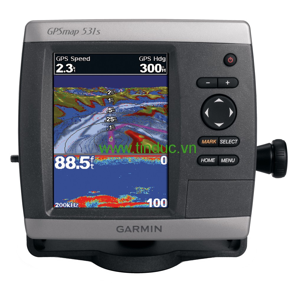
The GPSMAP 531s is a compact chartplotter that features an ultra-bright 5” (12.7 cm) QVGA color display along with an improved high-speed digital design for increased map drawing and panning speeds. It’s ready to go with a built-in, satellite-enhanced basemap preloaded with U.S. Garmin Lakes and an easy-to-use interface designed to help you navigate the open waters with ease. The GPSMAP 531s also accepts BlueChart® g2 Vision® cards (sold separately) for added features and functionality such as high-resolution satellite imagery, 3-D views and Auto Guidance technology.
Navigate the Lake
The GPSMAP 531s comes ready to go with preloaded U.S. Garmin Lake map data. For areas outside the U.S., the GPSMAP 531s has a worldwide basemap with satellite images in place of more traditional maps. The GPSMAP 531s also comes standard with a high-sensitivity GPS receiver for superior satellite tracking and quicker acquisition times. And with an SD™ card slot, it’s easy to add additional maps without connecting to a computer.
Get Sonar
The GPSMAP 531s comes with a powerful dual-beam transducer that clearly illustrates depth contours, fish targets and structures whether you’re fishing in freshwater or off the coast. The GPSMAP 531s also is NMEA 0183-certified for easy connectivity with sensors, instruments and future marine offerings.
Add Extras with Garmin Lakes Vision
With the optional Garmin Lakes Vision SD card, you can add a whole new dimension of exceptional features to your chartplotter.
- MarinerEye view and FishEye view provide you a 3-D perspective of map information, both above and below the waterline.
- High-resolution satellite images to help you orient yourself in unfamiliar areas.
- Auto Guidance technology searches through all relevant charts to create a route you can actually follow — one that avoids obstacles, shallow water, buoys and other obstructions.
Physical & Performance |
|
|
Unit dimensions, WxHxD |
5.9" x 6.4" x 2.9" (15.0 x 16.3 x 7.4 cm) |
|
Display size, WxH |
3.0" x 4.0"; 5.0" diagonal (7.6 x 10.2 cm; 12.7 cm diagonal) |
|
Display resolution, WxH |
234 x 320 pixels |
|
Display type |
QVGA display |
|
Weight |
1.75 lbs (0.8 kg) |
|
Water rating |
IPX7 |
|
Receiver |
High sensitivity |
|
Antenna |
Internal only |
|
Mounting options |
Bail with swivel or flush |
|
Power consumption |
Max power usage at 13.8 Vdc: 15 W Typical current draw at 12 Vdc: 0.6 A |
Maps & Memory |
|
|
Preloaded maps |
Inland Lakes (inland maps) |
|
Accepts data cards |
1 SD™ card |
|
Waypoints |
3,000 |
|
Routes |
100 |
|
Track log |
10,000 points; 50 saved tracks |
Features & Benefits |
|
|
Garmin Radar compatible |
No |
|
Garmin Sonar compatible |
Yes |
|
NMEA 2000® compatible |
No |
|
NMEA 0183 compatible |
Yes |
|
Garmin Marine Network™ compatible |
No |
|
Garmin SmartMode compatible (customizable monitor presets) |
No |
|
Supports AIS (tracks target ships position) |
Yes |
|
Supports DSC (displays position data from DSC-capable VHF radio) |
Yes |
|
Tide tables |
Yes |
|
Garmin Meteor Audio System compatible |
No |
|
Supports Fusion Lync compatible marine radios |
No |
|
GSD™ Black Box sonar support |
No |
|
GCV™ Black Box sonar support |
No |
|
SiriusXM™ Weather & Radio compatible |
No |
|
BlueChart® Mobile (planning) compatible |
No |
|
Garmin Helm compatible |
No |
|
GRID™ (Garmin Remote Input Device) compatible |
No |
|
Wireless remote compatible |
No |
|
Wireless mouse compatible |
No |
Sonar Features & Specifications |
|
|
Dual-frequency (50/200 kHz) sonar capable |
No |
|
Dual-beam (77/200 kHz) sonar capable |
Yes |
|
Frequencies supported |
77/200 kHz |
|
Transmit power |
500 W RMS |
|
CHIRP sonar technology |
No |
|
DownVü™ |
No |
|
SideVü™ |
No |
|
Voltage range |
10-32 Vdc input |
|
Maximum depth |
900 ft. (depth capacity is dependent on water bottom type and other water conditions) |
|
Bottom lock (shows return from the bottom up) |
Yes |
|
Water temperature log and graph |
Yes |
|
Sonar recording |
No |
|
Sonar history rewind |
No |
Connections |
|
|
NMEA 0183 input ports |
2 |
|
NMEA 0183 output ports |
2 |
|
Video input ports |
None |
|
Video output ports |
None |
|
Wireless connectivity |
No |
|
Garmin Marine Network™ ports |
None |
- GPSMAP 531s
- Tilt/swivel mount
- Protective front cover
- Power/data cable
- Documentation
- Dual beam transducer
Sản phẩm liên quan

Hiện tại chưa có ý kiến đánh giá nào về bài viết này. Hãy là người đầu tiên chia sẻ cảm nhận của bạn.