


Sản phẩm gợi ý
Danh mục
Giỏ hàng của bạn
Máy định vị GPSMAP® 547 đã được thêm vào giỏ hàng
Tiếp tục mua hàng Tiến hành đặt hàng »Máy định vị GPSMAP® 547


| Đặt hàng: |
Giao hàng trong 15 ngày |
| Bảo hành: | 12 tháng |
| Lượt xem: | 2967 lượt |
| Giao hàng: |
- Miễn phí giao hàng (Toàn quốc) cho đơn hàng từ 600.000 đ trở lên
- Miễn phí giao hàng đối với khách hàng Doanh Nghiệp, Dự Án, Đại Lý - Khách hàng được kiểm tra hàng trước khi thanh toán (đồng kiểm). Công ty phân phối các sản phẩm chính hãng trên toàn quốc. |
| Giá bán: | BÁO GIÁ NGAY TRONG 9 PHÚT |
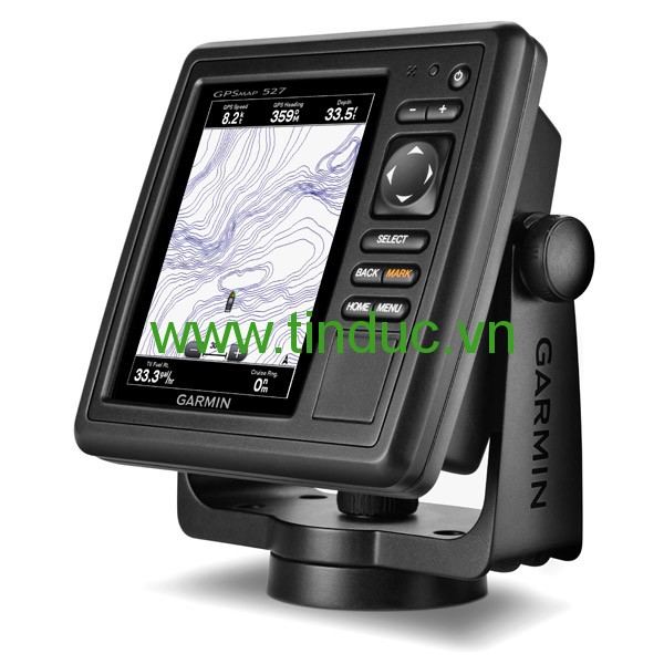
An Amazing Chartplotter
- 5" VGA display
- 10 Hz GPS/GLONASS receiver
- Wireless connectivity
- U.S. coastal and inland mapping
GPSMAP 547 allows for easy visibility, day or night. Whether it is flat, flush or swivel-mounted, it will be the focal point of your helm. It includes our hallmark user-friendly interface as well as U.S. coastal and inland mapping.
With the integration of a 10Hz GPS/GLONASS receiver, the 547 refreshes position and heading up to 10 times per second. It displays constant and fluid on-screen location and proves to be incredibly accurate when marking and navigating to any one of 5,000 user-created waypoints.
It also has wireless connectivity, giving you the opportunity to connect and access marine-specific apps via smartphone or tablet.
View and Control Your Device From an iPhone® or iPad®
Garmin Helm allows you to view and control your compatible Garmin chartplotter from an iPhone or iPad — while providing enhanced situational awareness for the mariner. Easily switch between portrait and landscape mode to accommodate mounting preferences. Using your Apple digital mobile device, you can even record a movie of your chartplotter screen to share with friends and family. Download from the App Store™ today.
Physical & Performance |
|
|
Unit dimensions, WxHxD |
5.9" x 6.1" x 2.4" (15.0 x 15.5 x 6.1 cm) |
|
Display size, WxH |
3.0" x 4.0"; 5.0" diagonal (7.6 x 10.2 cm; 12.7 cm diagonal) |
|
Display resolution, WxH |
480 x 640 pixels |
|
Display type |
VGA display |
|
Weight |
1.7 lbs (0.8 kg) |
|
Water rating |
IPX7 |
|
Receiver |
10 Hz high-sensitivity |
|
Antenna |
Internal with external connection |
|
Mounting options |
Bail with swivel, flat or flush |
|
Power consumption |
Max power usage at 10 Vdc: 27 W Typical current draw at 12 Vdc: 450 mA Max current draw at 12 Vdc: 2.7 A |
Maps & Memory |
|
|
Preloaded maps |
BlueChart® g2 (coastal maps) |
|
Accepts data cards |
2 microSD™ cards |
|
Waypoints |
5,000 |
|
Routes |
100 |
|
Track log |
50,000 points; 50 saved tracks |
Features & Benefits |
|
|
Garmin Radar compatible |
No |
|
Garmin Sonar compatible |
No |
|
NMEA 2000® compatible |
Yes |
|
NMEA 0183 compatible |
Yes |
|
Garmin Marine Network™ compatible |
Yes (limited capabilities) |
|
Garmin SmartMode compatible (customizable monitor presets) |
No |
|
Supports AIS (tracks target ships position) |
Yes |
|
Supports DSC (displays position data from DSC-capable VHF radio) |
Yes |
|
Tide tables |
Yes |
|
Garmin Meteor Audio System compatible |
Yes |
|
Supports Fusion Lync compatible marine radios |
Yes |
|
GSD™ Black Box sonar support |
No |
|
GCV™ Black Box sonar support |
No |
|
SiriusXM™ Weather & Radio compatible |
Yes |
|
BlueChart® Mobile (planning) compatible |
Yes |
|
Garmin Helm compatible |
Yes |
|
GRID™ (Garmin Remote Input Device) compatible |
No |
|
Wireless remote compatible |
No |
|
Wireless mouse compatible |
No |
Sonar Features & Specifications |
|
|
Dual-frequency (50/200 kHz) sonar capable |
No |
|
Dual-beam (77/200 kHz) sonar capable |
No |
|
CHIRP sonar technology |
No |
|
DownVü™ |
No |
|
SideVü™ |
No |
|
Voltage range |
10-32 Vdc input |
Connections |
|
|
NMEA 0183 input ports |
2 |
|
NMEA 0183 output ports |
2 |
|
Video input ports |
None |
|
Video output ports |
None |
|
Wireless connectivity |
Yes |
|
Garmin Marine Network™ ports |
1 |
- GPSMAP 547
- Power/data cable
- Tilt/swivel mount
- Flush mount kit
- Protective cover
- Documentation
Sản phẩm liên quan

Hiện tại chưa có ý kiến đánh giá nào về bài viết này. Hãy là người đầu tiên chia sẻ cảm nhận của bạn.