


Sản phẩm gợi ý
Danh mục
Giỏ hàng của bạn
Máy định vị GPSMAP® 740 đã được thêm vào giỏ hàng
Tiếp tục mua hàng Tiến hành đặt hàng »Máy định vị GPSMAP® 740


| Đặt hàng: |
Giao hàng trong 15 ngày |
| Bảo hành: | 12 tháng |
| Lượt xem: | 3576 lượt |
| Giao hàng: |
- Miễn phí giao hàng (Toàn quốc) cho đơn hàng từ 600.000 đ trở lên
- Miễn phí giao hàng đối với khách hàng Doanh Nghiệp, Dự Án, Đại Lý - Khách hàng được kiểm tra hàng trước khi thanh toán (đồng kiểm). Công ty phân phối các sản phẩm chính hãng trên toàn quốc. |
| Giá bán: | BÁO GIÁ NGAY TRONG 9 PHÚT |
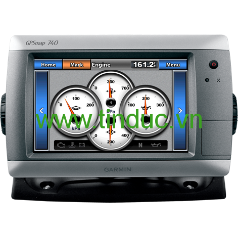
GPSMAP 740 is a stand-alone touchscreen chartplotter that brings a new level of functionality to your vessel. Featuring a brilliant 7" (17.78 cm) display, GPSMAP 740 puts all the information you need right at your fingertips. GPSMAP 740 is preloaded with U.S. coastal maps. In addition, GPSMAP 740 accepts radar input and offers full NMEA 2000® connectivity for greater convenience when adding extra sensors.
Explore the Seas
GPSMAP 740 contains preloaded map data for all U.S. coastal areas, including Alaska and Hawaii, plus Explorer Charts for the Bahamas. GPSMAP 740 also features an internal, high-sensitivity GPS receiver for superior satellite tracking and quicker acquisition times. And as an added benefit, GPSMAP 740 can receive graphical weather data for North America through the optional GXM™ 51 satellite receiver/antenna (sold separately).
Take Control by Touch
Input is easy with GPSMAP 740. Whether you’re changing course or simply reviewing information in front of you, the intuitive touchscreen interface makes for simple operation. The device also offers flexible brightness levels for daytime readability along with low-light dimming during night use. And with a widescreen display that’s rugged and waterproof, it’s made to perform in any situation.
Expand with Radar
Featuring a built-in radar port, GPSMAP 740 can be interfaced with Garmin’s line of affordable GMR™ marine radar systems (sold separately). Whether you’re adding radar now or in the future, you’ll enjoy the convenience of “plug-and-play installation” as well as the power, range and high-definition targeting of our proven radar offerings.¹
Add Extras with BlueChart g2 Vision
With the optional BlueChart g2 Vision SD™ card, you can add a whole new dimension of exceptional features to your chartplotter.
- MarinerEye view and FishEye view provide you a 3-D perspective of map information, both above and below the waterline.
- High-resolution satellite images and aerial photographs help you orient yourself in unfamiliar areas.
- Auto Guidance technology searches through all relevant charts to create a route you can actually follow — one that avoids obstacles, shallow water, buoys and other obstructions.
Physical & Performance |
|
|
Unit dimensions, WxHxD |
8.8" x 5.6" x 3.1" (22.4 x 14.2 x 7.9 cm) |
|
Display size, WxH |
6.0" x 3.6"; 7.0" diagonal (15.2 x 9.1 cm; 17.8 cm diagonal) |
|
Display resolution, WxH |
800 x 480 pixels |
|
Display type |
Touchscreen WVGA display |
|
Weight |
2.48 lbs (1.1 kg) |
|
Water rating |
IPX7 |
|
Receiver |
High sensitivity |
|
Antenna |
Internal with external connection |
|
Mounting options |
Bail or flush |
|
Power consumption |
Max power usage at 13 Vdc: 8.56 W Typical current draw at 12 Vdc: 0.6 A |
Maps & Memory |
|
|
Preloaded maps |
BlueChart® g2 (coastal maps) |
|
Accepts data cards |
1 SD™ card |
|
Waypoints |
3,000 |
|
Routes |
100 |
|
Track log |
20,000 points; 50 saved tracks |
Features & Benefits |
|
|
Garmin Radar compatible |
Yes |
|
Garmin Sonar compatible |
No |
|
NMEA 2000® compatible |
Yes |
|
NMEA 0183 compatible |
Yes |
|
Garmin Marine Network™ compatible |
No |
|
Garmin SmartMode compatible (customizable monitor presets) |
No |
|
Supports AIS (tracks target ships position) |
Yes |
|
Supports DSC (displays position data from DSC-capable VHF radio) |
Yes |
|
Tide tables |
Yes |
|
Garmin Meteor Audio System compatible |
No |
|
Supports Fusion Lync compatible marine radios |
No |
|
GSD™ Black Box sonar support |
No |
|
GCV™ Black Box sonar support |
No |
|
SiriusXM™ Weather & Radio compatible |
Yes |
|
BlueChart® Mobile (planning) compatible |
No |
|
Garmin Helm compatible |
No |
|
GRID™ (Garmin Remote Input Device) compatible |
No |
|
Wireless remote compatible |
No |
|
Wireless mouse compatible |
No |
Sonar Features & Specifications |
|
|
Dual-frequency (50/200 kHz) sonar capable |
No |
|
Dual-beam (77/200 kHz) sonar capable |
No |
|
CHIRP sonar technology |
No |
|
DownVü™ |
No |
|
SideVü™ |
No |
|
Voltage range |
10-32 Vdc input |
Connections |
|
|
NMEA 0183 input ports |
2 |
|
NMEA 0183 output ports |
2 |
|
Video input ports |
None |
|
Video output ports |
None |
|
Wireless connectivity |
No |
|
Garmin Marine Network™ ports |
None |
- GPSMAP 740
- Top and bottom snap covers
- Bail mount with built-in cable management
- Knobs
- Flush mount gasket and hardware
- Threaded power/data cable
- Protective cover
- Documentation
Sản phẩm liên quan

Hiện tại chưa có ý kiến đánh giá nào về bài viết này. Hãy là người đầu tiên chia sẻ cảm nhận của bạn.