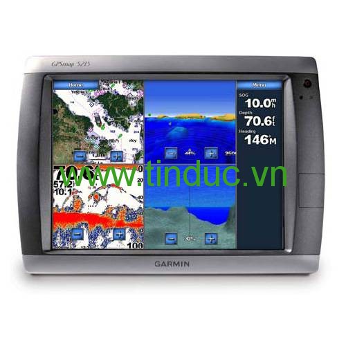
The GPSMAP 5215 offers true “big picture” navigation. Preloaded with BlueChart® g2 maps of the U.S. coast and a whopping 15" (38.1 cm) screen, the 5215 makes navigation as easy as pointing your finger. This chartplotter features the same menu-driven touchscreen found on its 5000 series counterparts. By connecting to the Garmin Marine Network, you can add sonar, radar and weather. And for even more advanced features, you can add the optional BlueChart® g2 Vision® card (sold separately).
View Detailed Graphics and Video
The GPSMAP 5215 features highly-detailed BlueChart g2 marine cartography of the coastal U.S., including Alaska, Hawaii and the Bahamas. For other areas, the 5215 has a worldwide basemap with high-quality satellite images in place of more traditional maps. With the SD™ card slot, you can add additional maps without having to connect to a computer.
The 5215’s huge XGA screen displays graphics with crisp, video-quality resolution. To keep tabs on your engine room or another area of your boat, you also can connect a live video feed with the 5215's video input/output options.
Add Extras with BlueChart g2 Vision
With optional BlueChart g2 Vision SD cards, you can add a whole new dimension of exceptional features to your chartplotter.
- MarinerEye view and FishEye view provide you a 3-D perspective of map information, both above and below the waterline.
- High-resolution satellite images and aerial photographs help you orient yourself in unfamiliar areas.
- Auto Guidance technology searches through all relevant charts to create a route you can actually follow — one that avoids obstacles, shallow water, buoys and other obstructions.
Connect to the Garmin Marine Network
The 5215 connects easily to the high-speed Garmin Marine Network, so you can interface with additional MFDs and add remote sensors. Once connected, you can share information between the 5215 and other chartplotters on your boat. You can also add high-powered radar, sonar, and XM satellite weather and radio to your system.
Physical & Performance
|
|
Unit dimensions, WxHxD
|
15.5" x 11.7" x 5.7" (39.4 x 29.7 x 14.5 cm)
|
|
Display size, WxH
|
12" x 9"; 15" diagonal
(30.41 cm x 22.81 cm; 38.1 cm diagonal)
|
|
Display resolution, WxH
|
1024 x 768 pixels
|
|
Display type
|
Touchscreen XGA display
|
|
Weight
|
11.9 lbs (5.4 kg)
|
|
Water rating
|
IPX7
|
|
Receiver
|
10 Hz high-sensitivity
|
|
Antenna
|
External only
|
|
Mounting options
|
Flush
|
|
Power consumption
|
Max power usage at 10 Vdc: 60 W
Max current draw at 12 Vdc: 4.2 A
|
Maps & Memory
|
|
Preloaded maps
|
BlueChart® g2 (coastal maps)
|
|
Accepts data cards
|
1 SD™ card
|
|
Waypoints
|
1,500
|
|
Routes
|
20
|
|
Track log
|
10,000 points; 20 saved tracks
|
Features & Benefits
|
|
Garmin Radar compatible
|
Yes
|
|
Garmin Sonar compatible
|
Yes (with GSD™ black box, sold separately)
|
|
NMEA 2000® compatible
|
Yes
|
|
NMEA 0183 compatible
|
Yes
|
|
Garmin Marine Network™ compatible
|
Yes
|
|
Garmin SmartMode compatible (customizable monitor presets)
|
No
|
|
Supports AIS (tracks target ships position)
|
Yes
|
|
Supports DSC (displays position data from DSC-capable VHF radio)
|
Yes
|
|
Tide tables
|
Yes
|
|
Garmin Meteor Audio System compatible
|
No
|
|
Supports Fusion Lync compatible marine radios
|
No
|
|
GSD™ Black Box sonar support
|
Yes
|
|
GCV™ Black Box sonar support
|
No
|
|
SiriusXM™ Weather & Radio compatible
|
Yes
|
|
BlueChart® Mobile (planning) compatible
|
Yes (Wi-Fi Adapter Kit required, sold separately)
|
|
Garmin Helm compatible
|
No
|
|
GRID™ (Garmin Remote Input Device) compatible
|
No
|
|
Wireless remote compatible
|
Yes
|
|
Wireless mouse compatible
|
Yes
|
Sonar Features & Specifications
|
|
Dual-frequency (50/200 kHz) sonar capable
|
Yes (with compatible black box sonar)
|
|
Dual-beam (77/200 kHz) sonar capable
|
Yes (with compatible black box sonar)
|
|
CHIRP sonar technology
|
Yes (with external black box)
|
|
DownVü™
|
No
|
|
SideVü™
|
No
|
|
Voltage range
|
10-35 Vdc input
|
Connections
|
|
NMEA 0183 input ports
|
4
|
|
NMEA 0183 output ports
|
2
|
|
Video input ports
|
2 - RCA composite
|
|
Video output ports
|
1 - VGA
|
|
Wireless connectivity
|
Yes (Wi-Fi Adapter Kit required, sold separately)
|
|
Garmin Marine Network™ ports
|
3
|
- GPSMAP 5215
- GPS 19x antenna
- Protective front cover
- Top and bottom snap covers
- Video cable assembly
- Power cable assembly
- NMEA 0183 cable
- NMEA 2000® drop cable
- NMEA 2000 power cable
- NMEA 2000 T-connector and terminator kit
- Flush mount hardware
- Flush mount gasket
- Marine grommet kit
- Manual case with owner's manual
- Quick reference guide
- Installation instructions


Hiện tại chưa có ý kiến đánh giá nào về bài viết này. Hãy là người đầu tiên chia sẻ cảm nhận của bạn.