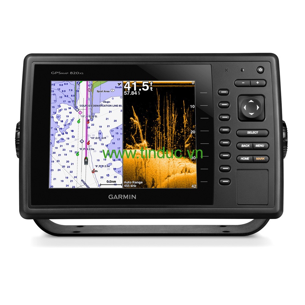
8" Keyed Chartplotter/Sonar Combo for Cruising, Sailing or Fishing
- Keyed chartplotter/sonar combo with 8” color SVGA display
- Preloaded U.S. LakeVü™ HD and BlueChart® g2 coastal maps
- Built-in Garmin HD-ID™ and supports CHIRP and DownVü™ scanning sonar with CHIRP technology
- High-sensitivity internal 10 Hz GPS/GLONASS receiver
- Supports all Garmin marine radar
The GPSMAP 840xs keyed chartplotter/sonar combo has a 8” color SVGA display and comes with preloaded U.S. LakeVü HD and BlueChart g2 coastal maps. HD-ID 1 kW sonar, CHIRP and DownVü with CHIRP sonar technology are built-in, allowing you the flexibility to choose from several optional transducers.
Extreme Sonar Capabilities
The built-in sonar capabilities of the GPSMAP 840xs gives you the freedom and flexibility to choose from several optional transducers, including 1 kW traditional, CHIRP and all-in-one HD-ID/DownVü scanning sonar with CHIRP technology. Add a GCV™ 10 black box sonar for both DownVü and SideVü™ scanning sonar with CHIRP technology (sold separately).
CHIRP Support
When used with a compatible CHIRP transducer (sold separately), GPSMAP 840xs displays crystal-clear sonar images detailing fishing hot spots, ship wreckage or a diving location. With Garmin CHIRP technology, you get remarkable target separation and resolution at extraordinary depths, and can dial into specific frequencies to target certain species of sport fish. Bottom contours are more visible, even at speed, and signal noise can be suppressed at greater depths to provide a more timely interpretation of what’s below for safer navigation and better fishing.
Dynamic Sea Temperature
Set a range for sea temperatures, and it dynamically adjusts to display a color range that can be used to target certain types of fish. (Optional GXM™ 52 required) .
Radar Support
Add your choice of marine radar, either open array or our new xHD dome radar that pair ease of use with advanced open array features.
Includes Inland and Coastal Mapping
The GPSMAP 840xs comes preloaded with both BlueChart g2 coastal maps and LakeVü HD, which features 17,000 U.S. lakes, of which more than 5,700 HD lakes have 1’ contours shoreline to shoreline. It's also compatible with optional mapping, LakeVü HD Ultra with MaxDef Lakes and BlueChart g2 Vision.
Super-fast 10 Hz GPS/GLONASS
High-sensitivity internal 10 Hz GPS/GLONASS provides position and
heading updates 10 times per second. It displays fluid on-screen location and proves to be incredibly accurate when marking waypoints and navigating.
NMEA 2000® Support
This combo allows you to add more capabilities to your boat. It provides NMEA 2000 support so you can see valuable information on your screen for Garmin autopilot, engine data, SiriusXM Weather radar and more.
Networking
The GPSMAP 840xs offers select networking capabilities that allow you to share features with other compatible GPSMAP units, such as radar, GCV 10 DownVü and SideVü scanning sonar, supplemental maps, and user data, including waypoints, routes and tracks. User data entered into 1 chartplotter can be automatically synced with other chartplotters in a network.
Special Sailing Features
Supported sailing features include laylines, enhanced wind rose, heading and course-over-ground lines, true wind data fields and tide/current/time slider.
GND™ 10 Black Box Interface
The GND 10 black box interface seamlessly integrates Nexus instruments and sensors with the Garmin family. It converts data between the Nexus network and NMEA 2000 to provide trouble-free compatibility between Nexus and Garmin products, including gWind™ and gWind Race wind transducers.
Compatible with gWind Transducers
Garmin gWind, gWind Wireless and gWind Race transducers feature twin-fin technology with 3-bladed propeller. Connect to the NMEA 2000 and compatible Garmin chartplotters via the GND 10 black box bridge.
Get Your Apple® Device Onboard with BlueChart® Mobile
With BlueChart Mobile, a free app downloaded from the App Store™, you can plan marine routes on your iPad® or iPhone® then wirelessly transfer them to your boat’s compatible networked Garmin chartplotter. Even if you don’t have a Garmin chartplotter, you can still take advantage of the tremendous features of BlueChart on your Apple device.
View and Control Your Device From an iPhone or iPad
Garmin Helm™ allows you to view and control your compatible Garmin chartplotter from an iPhone or iPad — while providing enhanced situational awareness for the mariner. Easily switch between portrait and landscape mode to accommodate mounting preferences. Using your Apple digital mobile device, you can even record a movie of your chartplotter screen to share with friends and family. Download from the App Store today.
Physical & Performance
|
|
Unit dimensions, WxHxD
|
11.5" x 7.4" x 2.9" (29.3 x 18.8 x 7.4 cm)
|
|
Display size, WxH
|
6.4" x 4.8"; 8.0" diagonal
(16.2 x 12.1 cm; 20.3 cm diagonal)
|
|
Display resolution, WxH
|
800 x 600 pixels
|
|
Display type
|
SVGA display
|
|
Weight
|
3.5 lbs (1.6 kg)
|
|
Water rating
|
IPX7
|
|
Receiver
|
10 Hz high-sensitivity
|
|
Antenna
|
Internal with external connection
|
|
Mounting options
|
Bail, flat or flush
|
|
Power consumption
|
Max power usage at 10 Vdc: 14 W
Typical current draw at 12 Vdc: 1.1 A
Max current draw at 12 Vdc: 3.2 A
|
Maps & Memory
|
|
Preloaded maps
|
BlueChart® g2 (coastal maps) and LakeVü HD (inland maps)
|
|
Accepts data cards
|
2 SD™ cards
|
|
Waypoints
|
5,000
|
|
Routes
|
100
|
|
Track log
|
50,000 points; 50 saved tracks
|
Features & Benefits
|
|
Garmin Radar compatible
|
Yes
|
|
Garmin Sonar compatible
|
Yes (built-in) and GCV™ black box compatible
|
|
NMEA 2000® compatible
|
Yes
|
|
NMEA 0183 compatible
|
Yes
|
|
Garmin Marine Network™ compatible
|
Yes (limited capabilities)
|
|
Garmin SmartMode compatible (customizable monitor presets)
|
No
|
|
Supports AIS (tracks target ships position)
|
Yes
|
|
Supports DSC (displays position data from DSC-capable VHF radio)
|
Yes
|
|
Tide tables
|
Yes
|
|
Garmin Meteor Audio System compatible
|
No
|
|
Supports Fusion Lync compatible marine radios
|
No
|
|
GSD™ Black Box sonar support
|
No
|
|
GCV™ Black Box sonar support
|
Yes
|
|
SiriusXM™ Weather & Radio compatible
|
Yes
|
|
BlueChart® Mobile (planning) compatible
|
Yes
|
|
Garmin Helm compatible
|
Yes
|
|
GRID™ (Garmin Remote Input Device) compatible
|
No
|
|
Wireless remote compatible
|
No
|
|
Wireless mouse compatible
|
No
|
Sonar Features & Specifications
|
|
Dual-frequency (50/200 kHz) sonar capable
|
Yes
|
|
Dual-beam (77/200 kHz) sonar capable
|
Yes
|
|
Frequencies supported
|
50/77/200 kHz, CHIRP (low, medium, high), DownVü
|
|
Transmit power
|
1 kW traditional; 600 W CHIRP
|
|
CHIRP sonar technology
|
Yes (Built-in)
|
|
DownVü™
|
Yes with CHIRP (built-in)
|
|
SideVü™
|
Yes (with GCV™ black box, sold separately)
|
|
Voltage range
|
10-32 Vdc input
|
|
Maximum depth
|
1,750 ft @ 50 kHz, saltwater, Garmin dual freq transducer @ 500 W
2,700 ft @ 50 kHz, saltwater, Airmar B260 transducer @ 1000 W
(depth capacity is dependent on water bottom type and other water conditions)
|
|
Bottom lock (shows return from the bottom up)
|
Yes
|
|
Water temperature log and graph
|
Yes
|
|
Sonar recording
|
Yes
|
|
Sonar history rewind
|
No
|
Connections
|
|
NMEA 0183 input ports
|
2
|
|
NMEA 0183 output ports
|
2
|
|
Video input ports
|
None
|
|
Video output ports
|
None
|
|
Wireless connectivity
|
Yes
|
|
Garmin Marine Network™ ports
|
1
|
- GPSMAP 840xs preloaded with LakeVü™ HD and BlueChart® g2 coastal maps
- Power/data cable
- Bail mount
- Flush mount
- Protective cover
- Documentation


Hiện tại chưa có ý kiến đánh giá nào về bài viết này. Hãy là người đầu tiên chia sẻ cảm nhận của bạn.