Navigate by land and by sea with the GPSMAP 620. This full-featured marine chartplotter pulls double duty with an automotive mode that’s ready to go as soon as you reach the shore when loaded with optional City Navigator® NT road maps for North America (sold separately). And to make sure you always know the way, the GPSMAP 620 comes standard with a high-sensitivity GPS receiver and brilliant, high-resolution touchscreen display.
Powerful and Portable
Featuring a marine and automotive mode, a high-sensitivity GPS receiver and a rugged case with waterproof (IPX7) design, the GPSMAP 620 is ready for your next outing. The 620 effortlessly shifts gears between marine and automotive modes. When supported by the marine mount, you’ll have at-a-glance access to your marine data. And when used with the optional automotive mount and City Navigator NT for North America map data, the automotive mode is automatically activated and the GPSMAP 620 becomes a robust on-the-road navigator.
Designed to Shine
With a brilliant 5.2" (13.21 cm) WVGA touchscreen display and an intuitive interface, you’ll have everything you need to navigate with confidence. The GPSMAP 620 comes preloaded with a worldwide satellite basemap for "view-from-space" imagery of shorelines and other surface features in the area.
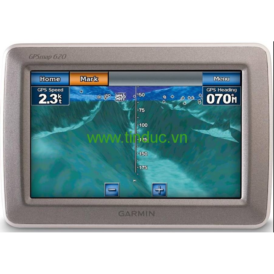
By Sea
In marine mode, the GPSMAP 620 provides 3-D MarinerEye view above the waterline, FishEye view below the waterline, and Auto Guidance technology that searches chart data to suggest the best passage with optional BlueChart® g2 Vision® data (sold separately). And you’ll always get the big picture with a worldwide basemap that comes standard on the GPSMAP 620. The GPSMAP 620 also is NMEA 0183 compliant, so it can be easily added to an existing marine network. And with access to fishing charts, tide and current data, marine services, coastal roads and more via optional BlueChart® g2 Vision data, you’ll always be in the know while you’re on the water.
By Land
In automotive mode, the GPSMAP 620 provides turn-by-turn directions that speak street names (with required City Navigator NT for North America data). And route planning has never been easier. Whether you’re searching for boat shops or bait shops, you’ll be able to plan the quickest and most efficient route. You also can create custom points of interests and set up proximity alerts to let you know what’s in your path as you travel down the road.
Physical & Performance
|
|
Unit dimensions, WxHxD
|
5.9"W x 4"H x 1.9"D (15.0 x 10.2 x 4.8 cm)
|
|
Display size, WxH
|
4.5"W x 2.7"H (11.4 x 6.9 cm); 5.2" diag (13.2 cm)
|
|
Display resolution, WxH
|
800 x 480 pixels
|
|
Display type
|
WVGA
|
|
Weight
|
17.3 ounces (490.4 g)
|
|
Water rating
|
IPX7
|
|
Receiver
|
High sensitivity
|
|
Antenna
|
Internal only
|
|
Mounting options
|
Bail with swivel or flush
|
|
Power consumption
|
0.6A at 12V; 0.3A at 24V
|
Maps & Memory
|
|
Preloaded maps
|
None
|
|
Accepts data cards
|
1 SD™ card
|
|
Waypoints
|
1,500 (marine mode)
1,000 (automotive mode)
|
|
Routes
|
50 (marine mode)
10(automotive mode)
|
|
Track log
|
10,000 points, 20 saved tracks (marine mode)
10,000 points, no saved tracks (automotive mode)
|
Features & Benefits
|
|
Garmin Sonar compatible
|
No
|
|
NMEA 2000® compatible
|
No
|
|
NMEA 0183 compatible
|
Yes
|
|
Garmin Marine Network™ compatible
|
No
|
|
Garmin SmartMode compatible (customizable monitor presets)
|
No
|
|
Supports AIS (tracks target ships position)
|
Yes
|
|
Supports DSC (displays position data from DSC-capable VHF radio)
|
Yes
|
|
Tide tables
|
Yes
|
|
Garmin Meteor Audio System compatible
|
No
|
|
Supports Fusion Lync compatible marine radios
|
No
|
|
GSD™ Black Box sonar support
|
No
|
|
GCV™ Black Box sonar support
|
No
|
|
SiriusXM™ Weather & Radio compatible
|
No
|
|
BlueChart® Mobile (planning) compatible
|
No
|
|
Garmin Helm compatible
|
No
|
|
GRID™ (Garmin Remote Input Device) compatible
|
No
|
|
Wireless remote compatible
|
No
|
|
Wireless mouse compatible
|
No
|
Sonar Features & Specifications
|
|
Dual-frequency (50/200 kHz) sonar capable
|
No
|
|
Dual-beam (77/200 kHz) sonar capable
|
No
|
|
CHIRP sonar technology
|
No
|
|
DownVü™
|
No
|
|
SideVü™
|
No
|
Connections
|
|
NMEA 0183 input ports
|
2
|
|
NMEA 0183 output ports
|
2
|
|
Video input ports
|
None
|
|
Video output ports
|
None
|
|
Wireless connectivity
|
No
|
|
Garmin Marine Network™ ports
|
None
|


Hiện tại chưa có ý kiến đánh giá nào về bài viết này. Hãy là người đầu tiên chia sẻ cảm nhận của bạn.